Wednesday, September 30, 2015

Nevada-Utah Vacation, Bryce Canyon National Park: September 27-30, 2015


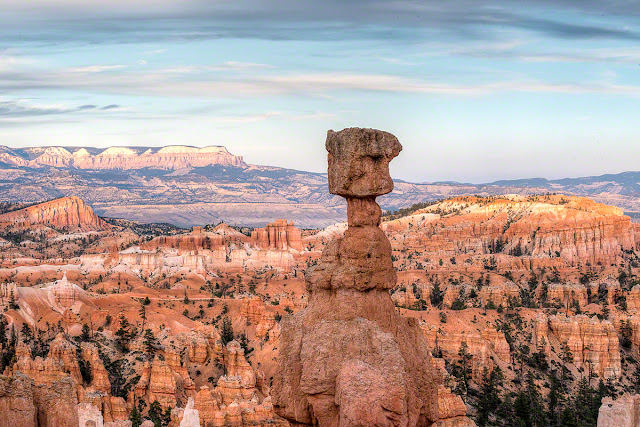
Our first night was spent in the Bryce Canyon Lodge near Sunset Point. Again, because our reservations were made at the last minute, we had one night in the lodge, one night in the nearby town of Panguitch, and the third night was back at Bryce Canyon Lodge near Sunrise Point. It was our first visit to this park and the scenery was startlingly beautiful with all of the gingerbread features of the hoodoos (rock formations). If landscape can be compared to architecture, I'd label this baroque. One of the more dominant hoodoos of the Navajo Trail is Thor's Hammer (shown above).


We were fortunate to be staying at the Bryce Canyon Lodge this first night because it was also the evening of the lunar eclipse. After hiking most of the day, we stationed ourselves below the canyon rim and next to a couple of other photographers who had apps to tell them where/when the moon would rise. At the canyon's rim from Sunset to Sunrise points there a hustle and bustle of tourists, photographers, park rangers with telescopes jockeying for position.


It was a beautiful, warm evening to watch the sunset and the moonrise. The moon came up with a bite already in it. 

More hiking the next day on the Queens/Navajo Loop Trail and the more difficult Hat Shop Trail.


The trees that grow in the "Wallstreet" portion of the Navajo Trail are Douglas Fir. The walls in this section are probably 200-300 ft high.


The Hat Shop trailhead is at Bryce Point and has a starting elevation of 8300 ft. As with all of the hikes in Bryce, the trail descends on the way into the canyon and you must climb out at the end. Hat Shop trail (4 miles/6.2 km RT) descends 1075 ft (328m) into the canyon. It didn't seem that steep on the way in, but it definitely did on the way out. 


Smiling on the way in and not so much on the way out.


As we were plodding back up to Bryce Point, the weather was becoming more and more threatening. There were dark clouds and thunder but thankfully no lightening because we had no way to shelter ourselves.


During the day and when my cell phone had a signal, I checked on my car. The garage finally looked at it about 4:30 pm on Monday. My car was diagnosed with a broken fuel pump and I was informed that it would take 5-7 days to get a new fuel pump and filter. Back on the phone with GEICO I was impressed at their efficiency. The closest repair shop (with good online reviews) that specialized in BMWs was about 200 miles away in Washington, Utah. The GEICO employee got approval to have the car towed to St. George, but it took a while to locate a tow company willing to make the journey. She had the entire office calling tow companies, and finally a willing tow company was located in Page, Arizona. Page was 300 miles from Escalante. Chris of Canyon Towing (928-660-2858) agreed to drive the 300 miles to Escalante, pick up my car, and deliver it 200 miles away to Washington, UT. He also agreed to let us ride with him. Chris said he'd leave Page at 6:30 am the next day and expected to arrive in Escalante about 10:00 am. 

Tuesday morning, Chris drove up in his pick-up truck and a vehicle transport trailer. We hopped into his truck and began the slow trip south to Bavarian Werkstatte in Washington, Utah.

Once at the repair shop, Enterprise Car Rental in St. George, UT, picked us up to take us to their shop where we rented a vehicle. We left there with a small GMC Terrain SUV. We drove through Zion National Park on our way back to Bryce. In the town of Springdale we picked up a young hitchhiking couple. They were hitchhiking because the Zion Park shuttle had stopped for the evening. They were trying to get back to the Zion Lodge where they both worked. Although dead tired, we took them to the lodge. As a thank you for getting them to the lodge, they gave us a red pass for the 4 days that we would be in Zion. That red pass allows you to drive your car to the lodge. Without the pass you must rely on the shuttle bus.

The next day, Chris (another one) of Bavarian Werkstatte confirmed that it was indeed a failed fuel pump that was ailing my car. He ordered the parts and said it would be ready in 1-2 days.

Our last day in Bryce, we did a relatively easy hike (compared to Hat Shop). We hiked a portion of the Fairyland trail that took us to a hoodoo called Tower Bridge. This trail had a descent of only 802 ft (245m). It was worth it!


Sunday, September 27, 2015

Nevada-Utah Vacation, Escalante National Monument: September 27, 2015


From Beaver, Utah, to Escalante National Monument it was an easy drive 2-1/2 hour drive. Escalante was the furthest point east that we planned to travel. Because this was a rather last minute trip, it was very difficult to get reservations in or near the parks in Utah. We managed to get a room for two nights in Escalante.

Escalante has not yet achieved national park status so it is not yet overrun with visitors. That also means that most of the off-highway roads are dirt or gravel and some require a 4-wheel drive to get to trailheads. This first afternoon we drove east toward Boulder to an easy to get to slot canyon located a few steps from the dirt road.


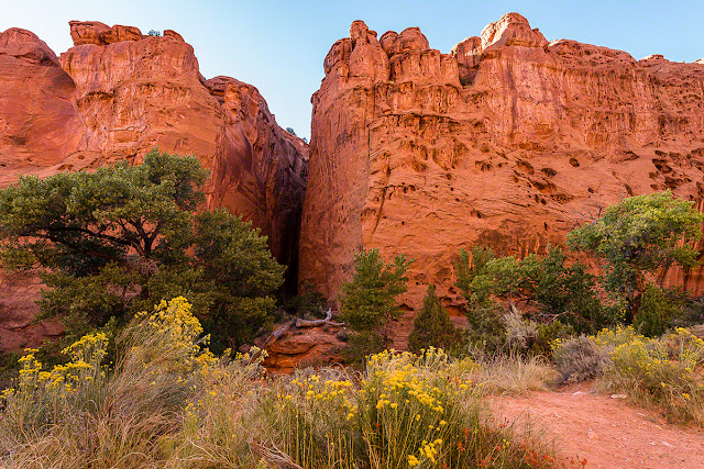
The rock walls of Long Canyon Slot were are a reddish orange with undertones of a deep maroon. On the way back to Escalante, we stopped on a hill to watch the moonrise.


The next morning, Saturday, we drove to Lower Calf Creek Falls trailhead. The trailhead is in a campground of the same name. The 3-mile trail which follows Calf Creek has interpretive signs that point out some of the highlights such granaries and pictographs made by the Fremont Indians about 900 years ago.


The 130-foot waterfall is at the end of the 3-mile hike. While this is a hot, sunny trail, the area around the waterfall is cool and lush.


On the way back to Escalante we took a 45-mile detour onto Hell's Backbone. The ranger at the Visitor's Center said that was a beautiful drive. It was not. It was 45 miles of bad, gravel, washboard road with again no cell phone coverage. There was very little area to see the views except where a bridge crossed the canyon.


It was a relief to be back in the town of Escalante. We stopped at the State Licensed Alcohol store to pick up a bottle of wine. Back in the car, the car refused to start. Feeling quite lucky that it waited until we were in town to fail, I contacted our insurance company to get roadside assistance. GEICO arranged to have the car towed about 1/2 mile down the street to a garage. While we waited for the tow truck, we had dinner with a glass of wine at the restaurant we were stalled in front of. The tow truck arrived, hooked up the car, dropped us at our room, then delivered the car to the garage which would not be open until Monday.

We were in Utah, and almost everything is closed on Sunday. The nearest car rental company was over 100 miles away and it was closed. There was no chance that we could get another night's room in Escalante. If we couldn't get transportation, we would be homeless. I had a sleepless, worried night mulling over all these dead ends. Dan slept well.

Sunday morning we called High Adventure Rentals in Escalante. Their website showed they rented ATVs and Jeeps for $250 for 4 hours. They also had a Lincoln Navigator SUV for rent, and they were open on Sunday. We walked to their shop and rented the huge Navigator for $89/day--a relief after seeing the prices for the off-road vehicles. So, with just a little hiccup in our vacation plans, we left our car and Escalante behind and drove to Bryce National Park a few miles west of Escalante.

Friday, September 25, 2015

Nevada-Utah Vacation, Great Basin National Park: September 24, 2015


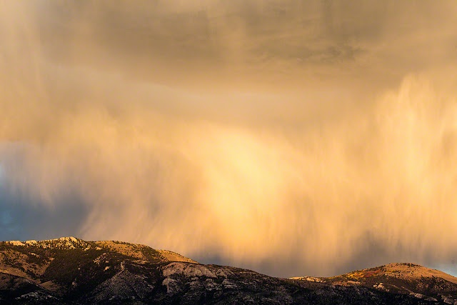
Our first day on the road was spent driving 410 miles to Ely, Nevada. Ely is on US Highway 50 nicknamed "The Loneliest Road." It does indeed feel like the loneliest road, and the scenery is a mostly unremarkable desert landscape of sage and sand. Driving into Ely just before sunset we were rewarded with a beautiful light show to the east. At the end of a side road we found a spot from which we could photograph the reflected sunset and the rain that wasn't touching the ground.


As the sun set in the west, the clouds to the east reflected its changing colors.


It was a magnificent ending to an otherwise uneventful day of driving.

The next day leaving Ely and Highway 50 behind, we drove to the Great Basin National Park which is the least visited National Park in the United States. The sign at Sacramento Pass caught my eye. The elevation is my birthday and I was born in Sacramento--nice coincidence.


The aspens of Great Basin National Park were in full fall color when we arrived this morning. When the sun hit their leaves each aspen looked like it was a lit candle among the dark patchwork of conifers.


After signing up for the afternoon cave tour, we took the Wheeler Peak scenic drive toward to Bristlecone Trailhead. Some Bristlecone trees are nearly 5,000 years old. They live so long because they are able to adapt to their environment often living in isolation where other trees can't survive. They are extremely slow growing. The sign on the tree below states:
A core was removed from this tree at a point four feet above the ground. the innermost growth ring has been dated at 1126 BC, therefore the tree was about four feet tall in that year. It may have taken as long as 200 years to reach that height; therefore, the tree is between 3100 and 3300 years old. 
This tree was born in 1150 BCE:


The Bristlecone trailhead begins at 9,800 ft (2,990m) and rises 600 ft (180m) along a 1.4 mile (2.3k) trail to where the Bristlecones begin.  


Back down near the 6,825 ft (2080m) Visitor Center, we caught up with the 90-minute Grand Palace Tour of Lehman caves. The caves were discovered in the late 19th century by who else but a guy named Lehman.  A ranger is the tour guide and our guide was fabulously informative and funny.


Once we finished the cave tour, we hurried back up the Wheeler Peak Scenic Drive to take photographs of the aspens in better light. The color was glorious.


The sun was beginning to set on our way out of the park. The highway that leads to the park is dotted with quirky sculptures. We stopped at "Too Tall Tony's grave" and photographed this sculpture until the sun disappeared.


Then it was back on the road to drive to Beaver, Utah, for the night. It was a long, dark drive along another lonely road with no services for 75 miles from the Nevada border. I worried the whole distance about running out of gas or my car quitting where there was no cell phone coverage. Dan slept.