Thursday, August 31, 2017

Dease Lake, BC to Whitehorse, Yukon: August 29-31, 2017


Today, August 29, we drove from Stewart to Dease Lake. We thought we had a reservation at the Arctic Divide Hotel. When we got there, we were turned away because they had not updated the computer and our confirmation was a mistake. The desk guy pointed us across the street and around the corner to the satisfactory Northway Motel. When we arrived at the Northway Motel, there were only 2 room left and we felt lucky to have one of them. When we asked what there was to do here, the owner said "nothing." Where are the restaurants? "There aren’t any. The Shack closed because the owner was having water problems. The Deli across the street closes at 3:30pm." It was 4pm. We went to the grocery store and bought some supplies: paté, raisin bread, crackers, and wine to supplement our emergency supplies of PB, jelly, cheese, crackers. Before our dinner of paté, cheese, crackers, we walked down to Allen Lake, sat on a couple of rocks, and had a paper cup of wine while trying to figure out where our next night would be spent.

As soon as we crossed into Canada, I bought a "Canada-Wide" sim card for my phone so we could call or use cell data to arrange our next nights and also in case of emergency. "Canada-wide" we discovered didn't mean the territories or even northern British Columbia. That means we have been at the mercy of whatever WiFi is available from the hotel/motel we find. Now, even with an emailed confirmation of a reserved room, there is no certainty of a reservation.

The next morning we had PB&J on raisin bread for breakfast. The hotel owner called ahead for us to hold a room (the pre-internet method) at the Yukon Motel and we drove to Teslin where the internet was better but the bed oh so uncomfortable. They did have a restaurant.

Between Dease Lake and Teslin we drove through quite a stretch of long ago burned over landscape.

The remains of a black spruce forest
Black spruce are tolerant of wet, swampy areas and bad soil. Even with such a wet environment, fire raged through this area years ago.


Leaving the Cassiar Highway and crossing into Yukon Territory, we headed west on Canada 1 (Alaska Highway) bound for Teslin. Along the way, we stopped at a small nature park, Rancheria Falls Recreation Site, for a short hike. 


A fluffy white lichen    

View of Teslin River and Nisutlin Bay National Wildlife Area 
Before leaving Teslin, we stopped in at a couple of First Nation Museums. We visited the George Johnston museum. George Johnston was a Tlingit Man who as a small child was brought inland. He was an early adopter before that term existed. He showed his entrepreneurial streak by  buying the first car (1928 Chevy) even though there were no roads, paying his friends to hack a 3-mile road, and then using his car as a taxi service. In the winter when the lake froze, his car was able to travel another 90 miles or so over the ice. He saw the frenzied construction of the Alaska Highway and the destruction of the Tlingit hunting grounds after the US joined WWII. He witnessed the dismantling of his culture and the demoralization of his people. In 1967 he returned his 1928 car to the dealer and bought a pickup. There wasn’t a dent on his car but there were layers and layers of paint. In the winter George painted his car white so it would blend in with the landscape and not be noticed by the animals he was hunting. In summer it became a dark green. George died in 1974. His car was restored and now is part of the excellent George Johnston Museum. Oh, and I should also say that when he was about 11 years old he ordered a camera from the Eaton catalog so for many years he documented life of the Tlingit in Teslin. Fabulous museum!


We had an easy drive to Whitehorse and stayed in the comparative luxury of the Edgewater Hotel. Next stop is Skagway. We will stay in Skagway two days and then taking the car ferry to Haines for another 3 nights. Yes, while we had decent WiFi, we scheduled several days in advance to take the pressure off. Neither Skagway nor Haines were in our thoughts when we began our drive two weeks ago. While traveling without an itinerary or advance reservations can be troublesome, it also allows us to blow in any direction like leaves in the wind.

Sculpture commemorating Whitehorse as the birthplace of McGee and McGrew (characters in poems by Robert W. Service)
The Cremation of Sam McGee (small excerpt printed here)
BY ROBERT W. SERVICE

There are strange things done in the midnight sun
      By the men who moil for gold;
The Arctic trails have their secret tales
      That would make your blood run cold;
The Northern Lights have seen queer sights,
      But the queerest they ever did see
Was that night on the marge of Lake Lebarge
      I cremated Sam McGee.

The Shooting of Dan McGrew

Monday, August 28, 2017

Glaciers and Bears, Hyder, Alaska: August 28, 2017


Salmon Glacier
The next morning on our way to Hyder and Fish Creek Wildlife Viewing Area, we spotted two bald eagles just sitting on a stump waiting for sun--a good omen for our bear viewing.


But, when we visited Fish Creek the only animals eating the salmon were the gulls. We spent a couple of hours at Fish Creek hoping for bears but struck out. Not a bear in sight. 

So, we drove the 40 minutes on a gravel, pot-holed road to the summit of Salmon Glacier. This is the 5th largest glacier in North America, and it's in Canada. While we crossed into the US for Fish Creek the road to the glacier crosses back into British Columbia. Salmon Glacier is a remnant from the Fraser Glaciation period that peaked about 14,000 years ago. The glacier sits at 4,300 feet. The weather at the top was in the mid 60s.

Salmon Glacier Panorama


The receding toe of Salmon Glacier
We returned to Fish Creek hoping to finally see bears. We were lucky. We saw one bear and he put on a great show. He is a sub-adult male grizzly about 1000 pounds. He had a great time fishing, and I had a great time watching his antics.


This grizzly's focus was only on fishing. The fact that 30 people with cameras were standing on a boardwalk just above him didn't distract him at all. 


When he was successful, we could hear the cracking of bones as he consumed his catch.


Sometimes, the fish got away, and his expression changed to a "boo-boo" face.


He ranged from one bank to the other looking for fish hiding in the shadows. He made time for back scratching when he ended up under low-hanging trees.


Before the bear came we discovered that some of the people at Fish Creek were kind of bear groupies. Several photographers had just come from Haines, Alaska, where they told us bears were plentiful. After watching this grizzly, we were smitten and added Haines to our itinerary.

Tomorrow we return to Highway 37 (Cassiar Highway) and resume our drive north through British Columbia to Yukon Territory.

Sunday, August 27, 2017

The Hazeltons, BC to Hyder, AK: August 27, 2017

'Ksan Historical Village, Hazelton, British Columbia
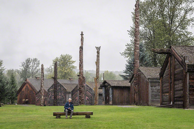
We had a bit of a drive to get from Burns Lake to Stewart but we still made time to stop at several First Nation Totem sites around The Hazeltons. 'Ksan is a reconstructed Gitxsan Village/museum at Hazelton. The Gitxsan people number about 10,000 around the world today. Approximately 3,500 Gitxsan people live in the Hazelton area.


Some of the totem poles at other sites around Hazelton are the oldest in Canada. It's pretty much impossible to capture the entire pole so I took photos of the beautiful detail in the totems. These totem poles are made from cedar and proclaim the owner's clan status and inherited family traditions. Clan crests portray mythical creatures, sometimes in human form, from the legendary history of the clan.


Near these totems is a small church, St. Paul's Church (Angelican/Episcopal), with an interesting bell tower that we also spent some time photographing.


Once on Highway 37 north (Cassiar Highway) we saw a bear wandering along the roadside. He did on the road what bears are supposed to do in the woods, and then he left.


Seeing a bear was a convenient segue to our next stop at Bear Glacier. Bear Glacier has receded quite far from the road. At one time, the road was higher because the glacier covered what is now the roadway.


We stayed two nights in Stewart, British Columbia. Stewart is just 3 miles or so from the US/Canada border and the town of Hyder. We crossed into Hyder, US (no border formalities) to visit the Fish Creek Wildlife Observation Site maintained by the US Forest Service and USDA. The salmon were running and the creek was filled with Chum and Pink Salmon trying to swim upstream to spawn and die. On the way back there were Canadian border formalities between Hyder and Stewart.

On our first visit, we saw lots of salmon but only a couple of black bears briefly emerged from the bushes. We bought a 3-day pass so we'll be back. The town of Hyder doesn't have much going on. It does have a post office, but most of the other buildings appear vacant. Leaving Hyder, there is the sign that proclaims it was "The Friendliest Ghost Town in Alaska."


Just caught seafood dinners in Stewart, British Columbia

From Crossing the Canadian-US Border to BC's Lake District: August 22-26, 2017


On the first and second days of our vacation, the air and sky were filled with smoke. On the third day of our trek north, the smoke disappeared and we were happy. On our fourth day on the road, the  daylight sky went totally dark when the moon stole the sun. We were not afraid. On the fifth day we took up to our “Bible of the North” (the Milepost) and crossed (at Alderwood) into the land of friendly people who don’t carry guns, do wear red and white hats appliquéd with maple leaves, and have national health care.

After the border crossing, we stopped near Chilliwack for a hike to Bridal Veil Falls. The falls and surrounding forest, both beautiful and large, were the perfect place to begin our unscripted, open-ended vacation.


We stayed in the town of Hope, British Columbia. Hope is the site of a World Chainsaw Festival and Competition every August. The sidewalks and street corners are littered with chainsaw art.


After admiring the chainsaw sculptures, we continued the drive north. We hoped to stay at 100-Mile House, but although Highway 97 is now open, most hotel rooms are occupied by firefighters, support personnel, and evacuees. Fires have been burning for several weeks in this part of BC. It is hot and windy and we're still wearing shorts.

The day before we left California (August 17), Highway 97 from Cache Creek to Williams Lake opened; however, the fires continue. In fact, four wildfires have joined into what is now called the Plateau fire. At the Cache Creek Visitor’s Center, we were told that the fire began in mid-July in nearby Ashcroft and traveled 12 kilometers in 12 minutes. 

The town of Clinton just north of Cache Creek, was under evacuation order from July 29 until yesterday (August 22) when the order was downgraded to an evacuation alert. We did find a room in Clinton, BC. The hotel manager told us that until today, the rooms were completely booked by firefighting staff and police. This is the first day that he has been able to rent any rooms to tourists. 

There is a certain symmetry to staying in Clinton the night after staying in Hope. 

Between the Hope and Clinton nights, we followed a diversion to Hell's Gate in Fraser Gorge. At only 110 feet wide, Hell's Gate is the narrowest and most turbulent section of the Fraser River. A sign outside the museum says that the gorge has always been an obstacle to transportation. Indians used ladders and road builders hung shelves to skirt its cliffs. The Fraser's water level fluctuates significantly, so fishways or fish ladders were built at several levels along the submerged canyon walls. The scenery was stunning.


So far it has been very hot and windy all along our way in British Columbia. Tomorrow we will continue north on 97 through the burned areas. We were told to expect smoke and slow areas due to fire fighting traffic. Rain is forecast tomorrow morning in Clinton. 

As forecast, we woke to drizzle in Clinton. Rain is badly needed in this area but we were told that it would take a week of rain to help with the fire suppression. The landscape is dry due to drought and a pine beetle infestation that hit the lodgepole pines. In places the burn was on both sides of 97 and despite the drizzle, a burnt smell stayed in the air. 

We continued north on Highway 97 in and out of rain and then east to Barkerville a reconstructed and restored Cariboo Canadian Gold Rush town. In the evening we strolled back through time to the 19th century. Actors/volunteers dressed in period costumes re-enact life in a gold rush town. Barkerville was named for miner Billy Barker who struck gold in 1862. At its peak, Barkerville was the largest city west of Chicago and north of San Francisco. Definitely worth the stop. 


The school house and St. Saviour's Anglican Church


Since we stayed at nearby Wells, BC, the next morning (August 25) we went back to Barkerville before our return drive to 97 to resume our trip north and west. The weather was changing and it was colder and grayer. One of the highlights was watching the Magistrate’s presentation called Simple Justice. He was a convincing magistrate, and we thoroughly enjoyed it. 

Barkerville Magistrate with framed portrait of Queen Victoria above
St. Saviour's Anglican Church was completed in 1870. Most of the interior, the stove, pews, plain glass windows are original. Services are held here throughout the summer months.


Returning to Highway 97 and Prince George, we continued west on Highway 16 to Burns Lake. We stayed two nights in Burns Lake; it was time to remind ourselves that we were on vacation and explore the area. Because we hoped to do some hiking, we bought bear spray to go with our bear bells.

Burns Lake is in the Lake District of British Columbia. The weather here is cooler and wetter. We did a little hiking and exploring of beautiful Francois Lake. Bears are supposed to be everywhere here, and all the hiking info says to use bear bells and carry bear spray. We did. Although we were the only people on the waterfall trail, there was so much jingling that it sounded like we were riding in Santa's sleigh. We didn't see any bears so either the bells worked or the bears weren't paying attention to the advertising. Despite the gray skies, we had just a little drizzle. 


Tomorrow we plan to get on the road early for two nights in Stewart. 


Memorable restaurant:
293 Wallace Street Restaurant, Hope, British Columbia - excellent