Saturday, December 31, 2022

Another Year of Memories: December 2022


West Brother Island in San Pablo Bay, California

We usually try to mark Dan's late December birthday by going somewhere new. Months ago I read in the New York Times' California Today email about the East Brother Light Station (EBLS) and B&B. I made our reservations for a time closest to Dan's birthdate, marked out the days on our calendar, and told Dan I was taking him somewhere but didn't tell him where. 

The day arrived and we drove to the Point San Pablo Yacht Harbor to wait for the 10-minute boat ride to the light station. At this point, Dan's beginning to figure out the destination. The water was rough, the skies were cloudy, and and it was windy as we arrived at the station.

East Brother Light Station (on our departure)
The Light Tower and Keeper's House (now the Bed and Breakfast)
Upon arrival at the station B&B innkeepers Brian and Stephanie gave us an interesting tour of the station and explained life at the station pre automation. East Brother Light Station was built in 1879 and automated in 1969. 
View of the Fog Signal Building and the round white cistern (foreground)
The water cistern was blasted to a depth of 30 feet (9.1 m) and is capable of holding 50,000 US gallons (190 m3) of rain water. Rain is the only source of water at the light station. 

We saw quite a few birds: Western Gulls, Black Oystercatchers, Cormorants, an Anna's hummingbird, and more. The gulls were constant visitors, and each had their regular spot on the edge of the island.


East Brother Light Station is almost on the dividing line between San Pablo Bay and San Francisco Bay. Both bays have numerous small rock islands. There are the Brothers (East and West), the Sisters, and the 5+ acre Red Rock Island among many others. Red Rock Island is just south of the San Rafael Bridge. It has the distinction of being the only privately owned island in either of the bays. It is for sale. Unfortunately, it sits in three counties: Marin, San Francisco, and Contra Costa. It has no structures and probably never will as a result of its tri-county position.

Red Rock Island
We were at the light station two nights. The weather continued to improve, the fog lifted, and the skies cleared. Our second day it was sunny and warm enough to have lunch outside. All the meals were wonderful. Breakfast and dinners were eaten with our fellow guests at a long dining table. Pre dinner we had wine/champagne and appetizers in one of the sitting areas next to a wood burning stove.


West Brother Island with Mt Tamalpais in in the distance
West Brother Island sits just a few feet away from East Brother Light Station. In the early years of the light station, the keepers kept milk goats tied on West Brother Island where they could be milked but couldn't eat the keepers' gardens. A small metal post used to secure the goats is still visible on West Brother Island.
East Brother Light Station and West Brother Island
We both thoroughly enjoyed our two days at the light station. Staying there was both interesting and very relaxing. 

A couple of weeks before the trip to the light station, a friend contacted me to say she and her son would be in San Francisco about the same time. They are Sri Lankans. We met Vatsala and her son Sheran (now 22) in 2006 in Sri Lanka. We had gone there as Earthwatch "volunteers" for a primate study in Polonnaruwa. For two weeks we chased macaques and sauntered after langurs (we didn't need to chase them), recording where they were and what they were doing. Their research continues at the Primate Center in Sri Lanka.

Through the years we managed to keep in touch so when Vatsala said they were coming to SF because Sheran was going to attend classes at SF Community College beginning in January I said I'd pick them up on Christmas Eve morning after we left the light station. And, we did. We brought them back to our house for three days. After the holiday period, we took Vatsala and Sheran to the Sacramento Amtrak station for their return to SF to continue apartment hunting. It was such a lovely visit, but we forgot to take photos of each other.

Sheran was successful in finding a place to live and will move in December 31.

Curious Cats

December was busier than the paltry number of photos I took this month would indicate. Early in December on a rainy evening I took photos for the Mountain Democrat of the Christmas Tree lighting in El Dorado Hills Town Center. Some people, like me, waited under cover for Santa to arrive, but these two little girls enjoyed everything about their evening out--even dancing in the rain.


A couple of weeks later with drier weather, Dan and I checked out Placerville's Main Street Christmas lights. This year Main Street had free hay rides in a tractor pulled wagon. 


Christmas Cheer along Highway 50

The cumulative total of deaths from Covid-19 in El Dorado County is 236 which since the end of October is an increase in five people who didn't get to enjoy this holiday season. One bright spot is that the death rate seems to be slowing and hospitals in our area are not overwhelmed by Covid patients. Perhaps there is really an end in sight to this pandemic.

One of the best December occurrences this year is rain. We've had several storms which have dropped copious amounts of rain in Northern California. Today, December 31, it seems like Mother Nature has turned all the spigots to full blast. We are getting rain, lots of rain! Yesterday we received 3.39 inches, and so far today another 3.50 (8.89 cm). The cumulative rainfall right now is 144.3% of normal for this date. At our house, today's rain will continue until midnight. New Year's Day will be sunny, and then another, cooler, multi-day atmospheric river will begin. While we are hoping that these rain days will lessen the fire danger in 2023, all that rainfall is bad news for some of the low lying areas. There have already been flooded areas and evacuations.

A seasonal drainage that hasn't had a stream in years

Happy New Year. Tonight we'll have our usual cheese fondue and champagne to welcome the New Year. Wishing you health and happiness in 2023. Make some great memories. Слава Украина

Thursday, December 8, 2022

Different Than Ordinary: December 8, 2022


Today was definitely a different than ordinary day with the acceptance of my photograph "Vermilion Flip Deux" by YourDailyPhotograph.com in their "Different Than Ordinary" theme. My photograph is available for sale and can be viewed at http://eepurl.com/ifFqIL.

Wednesday, October 26, 2022

Grand Canyon Road Trip, The Last Part: October 19 - 25, 2022


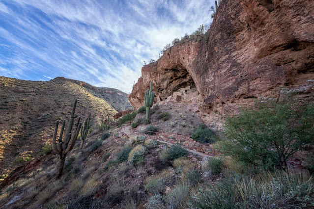
At our friend Sue During's suggestion, we took the scenic route from Grand Canyon to Oro Valley stopping at Tonto National Monument to see the cliff dwellings. We walked up to the lower cliff dwellings on a paved, half-mile path that ascends about 350 feet. There is another, farther set of cliff dwellings which require a reservation and a park service guide to get there. 

At least 10,000 years ago hunters and gatherers moved through the Tonto Basin area. With the introduction of agriculture, people began building more permanent structures for their homes. Around 1250 CE more people moved into the valley and hillsides. Some people lived in cliff dwellings built with adobe mud and surrounding rock. Roofs were made from wood as were door lintels. Water was gathered far below from the Salt River.


In stages rooms were added to the lower cliff dwelling alcove. At the last stage of construction as many as 17 households, or 68-119 people may have lived in this alcove.


For some reason by 1450 CE all the people living here had moved on to parts unknown.


Roosevelt Lake created in 1911 with the damming of the Salt River
Our next stop was our friend's home in Oro Valley. We met Sue Durling in 2005 on a rafting trip on the Firth River in the Yukon that ended at the Beaufort Sea of the Arctic Ocean. This was our second visit and it was good to catch up. We stayed two nights, had great meals and wandered around Tucson galleries and gardens during the day. 

Leaving Oro Valley on our way to Ajo (garlic in Spanish) we stopped at Saguaro National Park West. It is a bit of a drive from Oro Valley so our arrival time was late morning.We did some short hikes off the scenic drive and ended our exploration at Signal Hill to see the petroglyphs. To protect them, there is a barrier encompassing the top of the hill. There is also a sign that says "Rattlesnake Area" perhaps to dissuade those who aren't going to let a barrier stop them.  


As a result of the barrier, the best photo can be taken with a long lens from down below Signal Hill. 

Signal Hill Petroglyphs

Up on Signal Hill only a few of the petroglyphs are visible. We were here many years ago, perhaps the last time we visited Sue, and I don't recall the barrier, but so many people won't obey the rules and don't care about the damage they leave behind.

Our next stop was Organ Pipe Cactus National Monument which is right on the US-Mexico border. My car, although all wheel drive, isn't really made for dirt/gravel roads. The ranger said we could drive South Puerto Blanco Drive along the border but couldn't do the loop without a high-clearance vehicle. I found even just driving along the border disconcerting with THE WALL just feet away from the dirt road, but we did. Cell phone coverage was sketchy so this sign wasn't a comfort.


Here the wall is built on US territory and has a one-lane paved road on our side of it. When we were on the dirt road, a border patrol agent/vehicle was sitting on that paved road next to the fence. A few minutes later another border patrol pickup came zipping past my car with a load of migrant men (presumably).


We also came here to see Organ Pipe Cactus of which we didn't see many in the area we could travel.

Organ Pipe Cactus (left) Saguaro Cactus (right)
We stayed the night at the Desert Sonoran Inn in Ajo. Our friend Sue used to live in Ajo many years ago. Ajo is just 43 miles north of the border. It is a nice town trying to remake itself after the closing of the copper mine in 1985. The former Curley Elementary School is now the Desert Sonoran Inn. The rest of the Curley School has been converted to artist live/work spaces.  

Curley School (1919) now Artist Live-Work Spaces
A Spiked Bannister at Curley School
Immaculate Conception Church (1925)
Ajo Federated Church (1926)
Drive-In Restaurant converted to a Laundromat
There is a Saturday Farmers/Art market in the town square where javelinas can sometimes be found grazing the lawn. The present population consists of retired people, business owners, border patrol agents/families, and in 2019-2020 Wall construction workers. There is even a coffee roaster in town.

Our next destination was to visit friends (former neighbors Lee and Elaine) who have relocated to the Yuma area. On the way and at their suggestion, we stopped at the Painted Rock Petroglyph site. There are said to be about 800 petroglyphs on weathered basalt boulders scattered over an outcropping. On some boulders there are so many petroglyphs it's like the people who created them were talking over each other. 


The oldest Petroglyphs in the Western Archaic style of grids, rakes, ladders, and atlatis are attributed to the hunting and gathering culture that lived in this area between 7500 BCE and 1 CE.

Western Archaic Style of Petroglyphs
According to Wikipedia Painted Rock also bears the inscriptions of historic passers-by: "Juan Bautista de Anza passed near here during his 1775-1776 expedition; followed by the Mormon Battalion in the 1840s; the Butterfield Overland Mail; and countless numbers of pioneers. During World War II, General George Patton used this area as headquarters for tank training."

Some inscriptions left by modern visitors
The Gila Style is attributed to a farming culture that lived in the area about 300 BCE and 1450 CE. This style consists of designs of animals, human shapes, plants, circles, zigzags, and insects.

The Gila Style
Lee and Elaine live in the outskirts of Yuma and very close to the Barry M. Goldwater Range. I've seen so many of Elaine's interesting Wall photos on FB that I was hoping to see it myself. One day they graciously took us for a ride in their Side by Side out into the Barry M. Goldwater Range to see THE WALL. As this range is used for military practice, there are a lot of signs encouraging you to stay on the road. 


There is also a distress beacon that advises in both English and Spanish that if you need help to push the button and Border Patrol will arrive in 1 hour. The sign further states: "You cannot walk to safety from this point! You are in Danger of Dying if you do not summon help!"


Looking through the new wall to the old wall (Obama era)
The Old Wall
The New Wall

The new wall looks like a dark ribbon running over mountains and through the desert. It follows the contours of the landscape much the way the Great Wall in China did.


Everything about this two-week road trip was interesting. We saw things we hadn't seen before, we had great photo ops, we learned new stuff, we met up with old friends, and my car did very well.

Next stop: Home