Monday, April 5, 2021

California-Nevada Desert Road Trip, Part 5 the End: March 2021

South Tufas at Mono Lake, CA

We made good time from Panaca to Mono Lake. There wasn't much to take up our time along the way. We did stop at the abandoned Coaldale Junction and also Nevada's Boundary Peak (tallest mountain in Nevada) viewpoint. Had my heart and stomach set on a wonderful dinner at the Mobile Station restaurant (not a joke), but found out that the restaurant/service station is only open seasonally. It would not open for another month. Fortunately, the grocery was open. We bought frozen chicken pot pies to microwave at the hotel, but discovered that these chicken pot pies are supposed to be baked in a conventional oven. Managed to microwave them but the crust became more of a dumpling instead of a flakey, browned crust. Another trip to the grocery for a cup of chili from their hot food counter. It was a better choice.

Boundary Peak, NV
What remains of Coaldale Junction, Nevada

Our first stop in California was at Mono Lake's South Tufas. There wasn't a breath of air and the reflections of snow topped mountains and tufa formations on the lake were even more beautiful.

Tufa towers are created when calcium-rich fresh water springs bubble up through the lake bottom and the calcium bonds to carbonates in the lake water to form a type of limestone called calcium carbonate. This is a gradual process that stops completely when the lake level drops.

In 1941 the lake level began to drop precipitously when the City of Los Angeles extended its aqueduct system into the Mono Basin to divert water from four of the six mountain streams that feed Mono Lake. With reduced freshwater inflow the lake lost more to evaporation than it gained from its inflow. "Mono Lake dropped nearly 50 vertical feet, shrank to half of its volume, and doubled in salinity over the next 40 years." Just like what has happened with the Salton Sea, miles of newly exposed lake bottom created unhealthy and unsightly dust storms in the windy Basin. 

Additionally, researchers found "if the lake continued to drop and increase in salinity, there would be a total ecosystem collapse. The decreasing lake level caused the islands where California Gulls nest to become connected to the mainland [which gave coyotes easy access to the nests]. The brine shrimp and alkali flies which millions of migratory birds depend on were also threatened, due to the increasing salinity."

In 1978 the Save Mono Lake movement began. In 1983 the California Supreme Court found that "the human and environmental uses of Mono Lake  . . deserve to be taken into account. Such uses should not be destroyed because the state mistakenly thought itself powerless to protect them."

In 1990 the court ordered that the Los Angeles Department of Water and Power's activities must comply with Fish and Game Code laws to protect fisheries in the creeks below the diversion points. In 1994, the State Water Resources Control Board negotiated an agreement between parties that the lake must be raised to an elevation of 6392 feet which was expected to take about 20 years. That elevation level is 25 feet lower than when the diversions began but 19 feet higher than it was in 1994. An informative online self-guided tour and map of the lake can be found here

Petrified Springs
When the lake level drops and exposes the tufa towers, the fresh water springs no longer percolate up through or around the towers leaving a petrified spring and stranded tufa towers.


The next morning we got up at sunrise when it was 23℉ and went back for more photos. The moon had yet to set.


The stranded tufa towers and much of the vegetation reminds me of what a coral reef looks like. Some of these bushes look like they could be fan corals.


After packing up, we stopped at the National Park visitor center overlook for a last look at the quiet serenity of Mono Lake. 


One sign pointed out that standing 13,000 years ago at the spot that I took this photo I would have been nearly 200 feet under Ice Age Mono Lake.

Ten days away from home to photograph geologic formations, animals, and learn about water-rights fights. I almost feel like our lives are gaining some normalcy. It was a great getaway. Next stop: Home.

We were gone just 10 days, but Spring was definitely in full swing. The wisteria was budding out and flowers were blooming everywhere at home.


California-Nevada Desert Road Trip, Part 4: March 2021

It's not a long drive from Valley of Fire State Park to Cathedral Gorge State Park. Even though these two parks are relatively close to each other they have very different geologic formations. The spires and gorges in Cathedral Gorge were created by volcanoes, earthquakes, water, and erosion. 

According to the Park Service brochure: Less than one million years ago, this area was covered by a freshwater lake. Sands and clays were washed down from the surrounding mountains into the lake eventually filling the valley to a depth of almost 1400 feet. Uplift and faulting caused the waters of the lake to drain away (part of the Colorado River drainage). As the lakebed was exposed, torrential rains washed gravels down onto the sediments from the nearby mountains. The erosion process continues today with Meadow Valley Wash and its tributaries cutting deeply into the silts and clays of the former lake bottom to create the gorges and spires of the Cathedral Gorge landscape. The old lakebed is carried 100 miles downstream to Lake Mead.


There are few trees in this park. The only shade is that cast by the spires. The coolest place to be is inside one of the slot canyons that wind through the formations. They weren't long but they were refreshingly cool inside.


We stayed in the nearby small town of Panaca. Panaca, settled by Mormon pioneers in 1865, is the second oldest town in Southern Nevada. The word "panaca" is the Southern Paiute word meaning "metal." 

Modern day Panaca has no restaurants but it does have the Pine Tree Bed and Breakfast. We rented their cabin which was separate from the house and very roomy. For lunch/dinner we had to drive to either Caliente or Pinoche. Residents of these towns make periodic trips (2 hour-drive) to St. George, Utah, to stock up on groceries.

Caliente has two open restaurants. We enjoyed the Side Track Cafe near the tracks. 

Social Distancing at the Side Track Cafe

Because we pretty much did all the hikes and exploring of rock formations on our first afternoon, we filled the next day with exploring Pioche and hiking at another park.

Pioche was considered to be one of the wildest mining camps in the west during the 1870's. Hired guns were recruited to keep the peace. It is no longer wild but has some interesting historical sights. The aerial tramway for transporting mined rock still hangs above the town. It also has an open restaurant, The Silver Cafe, and a grocery store.

In 1874, Pioche became the county seat of Lincoln County. The new courthouse was designed in 1872 and had a construction budget of $26,400. Contracts were broken and construction costs increased. Bonds were issued but not paid. In 1907, new bonds were issued with a repayment plan. In 1938, two years after the building was condemned, the final cost was over $800,000 and the reason it is called the "Million Dollar" courthouse.

The "Million Dollar" Courthouse
The Fire House
Pioche's Modern Era Movie Theater (closed)

From Pioche we drove to Echo Canyon State Park to hike the Ash Canyon Trail recommended by one of the Eastern Nevada park rangers. 

View of Echo Canyon Reservoir from the Ash Canyon Trail
We scrambled over huge boulders and hiked through canyons with 300 feet walls ending back near the road and the Echo Canyon stream.


While we tried to find a trail across the road so we didn't have to walk along the road, it was still too wet over there to make much progress. So, it was back to the road to make our way to the campground and our car.


Tomorrow, we begin the drive back to California and home. Next stop, Lee Vining, California, and Mono Lake.

Sunday, April 4, 2021

California-Nevada Desert Road Trip, Part 3: March 2021

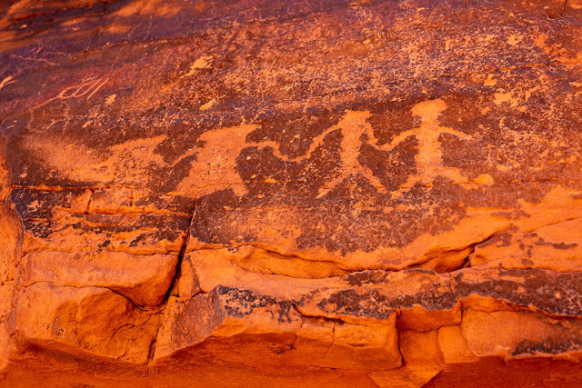
Petroglyph symbolizing spirit figures (left) holding hands with humans (right)

We spent an entire day at Valley of Fire State Park in Nevada departing for a late lunch and returning for the late afternoon light. The park is about 1 hour northeast of Las Vegas. Unfortunately, we were here on a Spring Break weekend and day trips to the park run from Las Vegas. It was a little busy on the more popular trails. 

Valley of Fire is named for the red sandstone (called Aztec Sandstone) formations "formed from great shifting sand dunes during the age of dinosaurs 150 million years ago."

We began exploring at the Mouse's Tank trail which runs through a petroglyph canyon. There are no signs pointing out the location of petroglyphs, but looking carefully we found them on swaths of black covered rocks. The black (desert varnish) was like an ancient blackboard for these ancient people. The glyphs are made by pecking the designs into the black desert varnish on the rocks. "The span of approximate occupation has been dated from 300 BCE to 1150 CE." These rock art designs would have been created within that approximate period. They have suffered from centuries of erosion and in some places only fragments remain.


The next hike was the Fire Wave Trail and Seven Wonders. All hikes at this park are on the AllTrails app. That made hiking easier because this trail is not well marked. 

As we walked along the striped rock on the Fire Wave Trail, I noticed to my right that a group of big-horn sheep were walking parallel to us at a lower level. We tiptoed over and were rewarded with a chance for photos. They didn't seem too concerned about the nearby human animals.


Continuing beyond Fire Wave Trail to the Seven Wonders we first walked through the very narrow, smooth rock Pink Canyon.

Leaving the Pink Canyon the colors returned to vibrant oranges. (NOTE: I did not add vibrance or saturation to these photos.)


Toward the end of the hike, we found Crazy Hill which looks like someone poured pastel colored paint on its slope.


We took a break from hiking and stopped by the visitor center where we found more Bighorn Sheep voraciously eating and mostly ignoring us human animals. Even though the sheep were sandwiched between the road and a crowd of people, they continued to eat. 


There is no food in the park so we drove back to Overton to have a late lunch. Back again in Valley of Fire, we went in search for Atlatl Rock. The petroglyphs there are of the atlatl and show how it was used. An atlatl (spear thrower) is a stick used by early peoples to propel a spear farther.

Later in the afternoon now and with better light, we headed back to Fire Wave Trail. On the way, we stopped with the other cars because there were once again a group of Bighorn Sheep on the rocks above the road.

The beautiful formations and striated rock along the Fire Wave trail.

There were still quite a few people here mostly taking selfies. I noticed the bighorn sheep were working their way toward us so we sat and waited and hoped they'd come near, and they certainly did.

A Heavily Pregnant Bighorn Sheep


The park's literature states that it is rare to see bighorn sheep in the park. New babies, beautiful light, four sightings of bighorn sheep, petroglyphs, and a full moon. Amazing day!

Until next time ....

Next stop: Cathedral Gorge State Park, NV